for those of you who are actually running outside and want to know how far you are running, here is a little tip:
use google earth!
to get started, go to earth.google.com and download and install the program.
once the program is installed it will take you to a page that has a tool bar on the left side. just type your city/state in the "fly to" box and it will take you there. just zoom in to get closer by using the wheel on your mouse (hint - on the bottom left you can check "roads" and it will show you the exact roads so you know where you are)
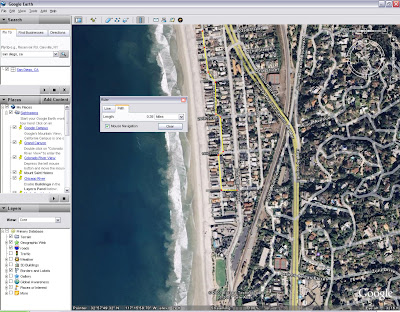
so, find your starting point and then click on the little blue ruler on the toolbar on top. then make sure when the box pops up that you click on the path tab. this will allow you to draw out your path and show a running tally of miles. now click on the map where you started, and continue clicking on your route (ie - start at home, click on the corner you turned on, then on the next corner... kind of a connect the dots thing.) do this for your whole route to see how far you went (don't forget the trip home too!) your mileage will show in the little ruler box. i hope these directions make sense!
i did this for the route amy and i ran/walked the other day (when i lost and then found the blankie) and it turns out we went almost 4 miles! i had no idea! cool stuff...
so, maybe we won't have to drive around watching the odometer looking for the perfect route anymore?


1 comment:
Awesome Lup- I tracked our mileage from yesterday and it was 3 1/2. Yeah. Cool tip. Thanks.
Post a Comment